








Key metrics
0
regional transport corridor
0
of road upgrades defined
0
of bridge upgrades proposed
We delivered a robust Business Case and preliminary design for upgrading three critical bridges on Fitzroy Developmental Road, addressing long‑standing safety constraints on a key OSOM and road train route.
Through innovative risk-led planning, live risk management, and a defensible cost–benefit framework, our experts provided clear, buildable solutions that improve safety, enable efficient freight movement, and support ongoing economic prosperity for the local and regional community.
At a glance
- We developed a clear, defensible Business Case Report for upgrading three constrained bridges on the 235 km Fitzroy Developmental Road, supporting investment decisions on a critical Central Queensland freight and livestock corridor.
- By addressing narrow 6.1 m bridge widths on a 100 km/h MCV and OSOM route, our solution improves safety for road trains, over‑dimension vehicles and general traffic, reducing collision and maintenance risks.
- Preliminary designs enable wider loads and longer road trains (up to PBS Level 4A), directly supporting the evolving needs of the mining and livestock industries.
- A live risk register and concept estimate ensured constructability, road user needs and safety risks were properly accounted for, providing confidence in cost and delivery outcomes.
- The proposed upgrades strengthen a vital regional link, improving freight efficiency, resilience and long-term economic prosperity for local communities.
Improving safety on a critical regional freight route
The Fitzroy Developmental Road is a 235km long state-controlled road located in Central Queensland connecting the Peak Downs Highway west of Nebo and the Capricorn Highway at Dingo.
The link is designated as a multi-combination vehicle (MCV) route, suitable for road trains up to 36.5m in length (Performance Based Standard Level 3A) operating at the general mass limits (GML). The route is regularly used by over size over mass (OSOM) vehicles with vehicle widths that may exceed 8m and masses that are governed by access permits.
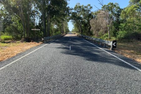
Fitzroy Developmental Road has a posted speed limit of 100km/h and typically provides a minimum sealed pavement width of 8m but narrows to 6.1m kerb to kerb at the Harrybrandt Creek, Isaac River and Isaac River overflow bridges.
This project originated from safety concerns of MCVs passing each other on the narrow bridges. Future development of the route supports the proposal to widen these structures as the mining industry is pushing for wider loads and the livestock industry are advocating for longer road trains, up to 53.5m (Performance Based Standards Level 4A), for stock movements. Maintenance of the existing structures is also a concern as the railings continue to be damaged by OSOM vehicles.
Balancing safety, constructability and future demand
A Business Case Report was developed for replacement of Harrybrandt Creek, Isaac River and Isaac River overflow bridges on Fitzroy Developmental Road including realignment of bridge approaches. The recommended works included three new bridges with a total length of 135m.
The project targeted locations with crash rates more than three times the route average, on a corridor carrying ~930 vehicles per day, with ~28% heavy vehicles, including MCVs and OSOM loads.
Civil, structural and transport planning specialists worked alongside cost, risk and flood experts to develop 3.7 km of road upgrades and three new bridges totalling ~135 m, designed to current TMR and AS5100 standards.
Designs support PBS Level 3A road trains (36.5 m) and future PBS Level 4A vehicles (up to 53.5 m), responding to growth from the mining and livestock sectors.
A live risk register and probabilistic cost estimates (P50/P90) improved confidence in constructability, safety and funding decisions, reducing long‑term maintenance and unplanned disruption for regional communities.
Supporting long-term economic prosperity
- We delivered an investment‑ready Business Case and preliminary design for upgrading three bridges on a 235 km strategic MCV and OSOM freight corridor.
- Our experts defined 3.7 km of road upgrades and three new bridges totalling 135 m, removing critical 6.1 m‑wide safety constraints at key river crossings.
- We enabled safe operation of PBS Level 3A (36.5 m) road trains and future Level 4A (up to 53.5 m) vehicles, supporting mining and livestock industries.
- Our team applied a live risk register and robust cost–benefit analysis, giving the client confidence in safety, constructability, costs and funding decisions.
- We improved road safety, reduced asset damage from OSOM vehicles, and strengthened long‑term economic outcomes for local and regional communities.